Views From Space: How Intense Summer Heat and Drought Have Scarred Europe's Terrain
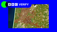
The essential natural environments of Western Europe—ranging from winding rivers and expansive farmlands to lofty mountain peaks—show clear signs of damage from intense summer heatwaves and enduring dry spells. By examining satellite photographs, an investigation by BBC Verify, which builds upon findings from BBC Science, has illustrated the severe and far-reaching ecological toll, depicting a continent facing historic levels of climate-related strain.
Looking down from orbit provides a grim illustration of how bad the situation has become. Lush green valleys and active streams have turned dry and shrunken. Key rivers that are vital for shipping, watering crops, and supporting local habitats have experienced dramatic drops in water levels, leaving dry riverbeds visible across numerous areas. This shortage threatens not only underwater species but also the supply of drinking water and industrial water resources.
Farming areas throughout the region have suffered heavily from the extreme temperatures and absence of rain. Fields that should be bursting with healthy crops are instead filled with dying plants and parched, cracked soil. This extensive agricultural damage raises major alarms regarding food supplies and farmers' incomes, threatening to cause economic disruption in hard-hit regions as harvest volumes shrink.
Europe's mountain ranges, which are usually thought to be more durable, are also showing unmistakable signs of ecological damage. Plant life on mountain slopes looks dehydrated and dying, which raises the hazard of forest fires that have already devastated various parts of the continent lately. The lasting consequences for delicate alpine habitats and native wildlife are severe, pointing to a disruption of traditional ecological cycles caused by rising global temperatures.
This detailed study by BBC Verify highlights how essential satellite monitoring is for tracking environmental shifts on a grand scale. Earth-observation technology delivers crucial information, enabling researchers and government officials to measure the scale of the destruction, track current trends, and comprehend the wider consequences of these severe weather patterns across the entire continent.
These orbital images offer a striking warning about the rising frequency and severity of extreme weather events striking Europe. Although seasonal shifts are normal, the magnitude and regularity of these current patterns match scientific forecasts for a warming planet, sparking critical conversations on how to adapt and reduce emissions over the long term.
While various independent media outlets cover these transformations, the data gathered from space provides an indisputable archive of Europe's changing climate. The dried-out terrains seen from above are far more than just striking pictures; they represent a serious environmental crisis that requires ongoing focus and joint efforts from political leaders, local populations, and the scientific community.


Comments (0)
Be the first to comment.
Join the discussion